AeroOps: Streamlining Enterprise Drone Operations Management
A comprehensive management software for drone operators - Drone service providers, pilots, aviation training organisations.
Managing a commercial drone fleet is a complex balancing act of logistics, compliance, and technical execution. As operations scale from a single pilot to a multi-regional team, the spreadsheets and manual logs that once worked become critical bottlenecks.
Enter AeroOps, an enterprise-grade platform built to unify every facet of drone operations into a single, high-performance dashboard.
The Problem: Fragmentation at Scale
Scaling a drone operation introduces a compounding set of logistical and technical challenges. Managing a single drone is simple; managing a fleet across different geographic zones is a complex systems-engineering problem.
Currently, operators face three major pain points:
- Disconnected Data Silos: Flight logs, maintenance records, pilot credentials, and mission planning often live in completely separate, non-communicating systems. Crucially, pilots are also forced to toggle between different apps just to check localized weather updates and secure airspace authorizations.
- Reactive Maintenance: Hardware failure in the field is costly. Without predictive tracking, maintenance is reactive rather than preventative.
- Friction in the Data Pipeline: Transitioning from field capture to GIS or AI/ML processing requires manual data handoffs, increasing the risk of human error and delaying time-to-insight.
The Solution: Core Features of AeroOps
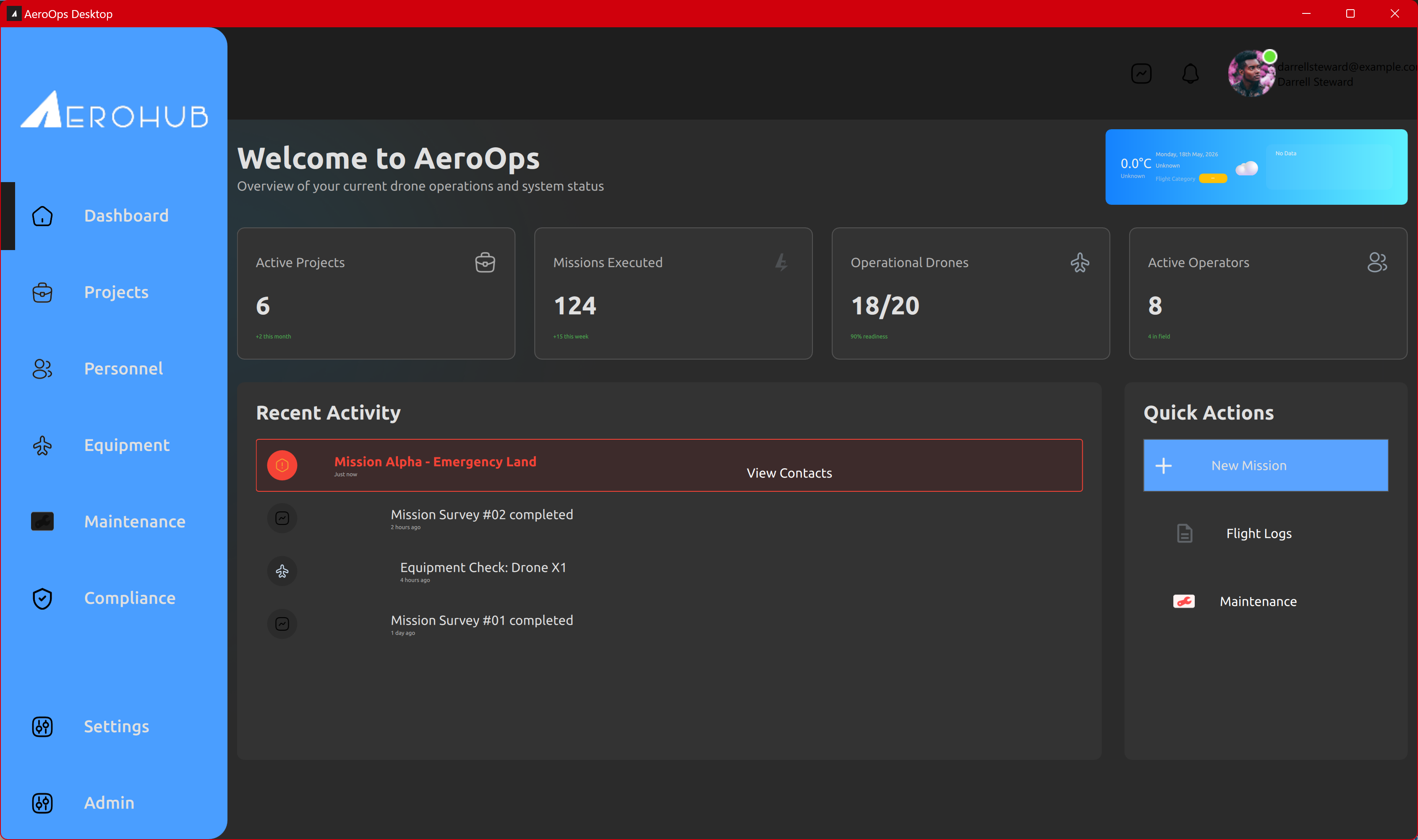
AeroOps is designed with a systems-level approach, bridging the gap between mechanical hardware management and intelligent software workflows. It serves as the single source of truth for drone service providers.
1. Unified fleet and asset oversight
AeroOps tracks the entire lifecycle of every component in your hardware inventory. Track battery health, airframe flight hours, and maintenance schedules automatically. By integrating directly with flight controllers, AeroOps automatically triggers maintenance alerts before mechanical failures occur in the field.
2. Live Telemetry & Mission Control
During active missions, AeroOps acts as a centralized command center. Stream live HD video and critical flight telemetry (GPS, airspeed, battery levels) directly to stakeholders anywhere in the world. This real-time visibility ensures that decisions are made based on accurate, up-to-the-second data.
3. Automated Compliance, Flight Logging and report generation
Forget manual data entry. AeroOps automatically synchronizes flight logs after every mission, capturing everything from pilot credentials to environmental conditions. The platform then takes this a step further with automated report generation, instantly compiling flight data, compliance records, and mission outcomes into exportable formats for stakeholders and regulatory audits.
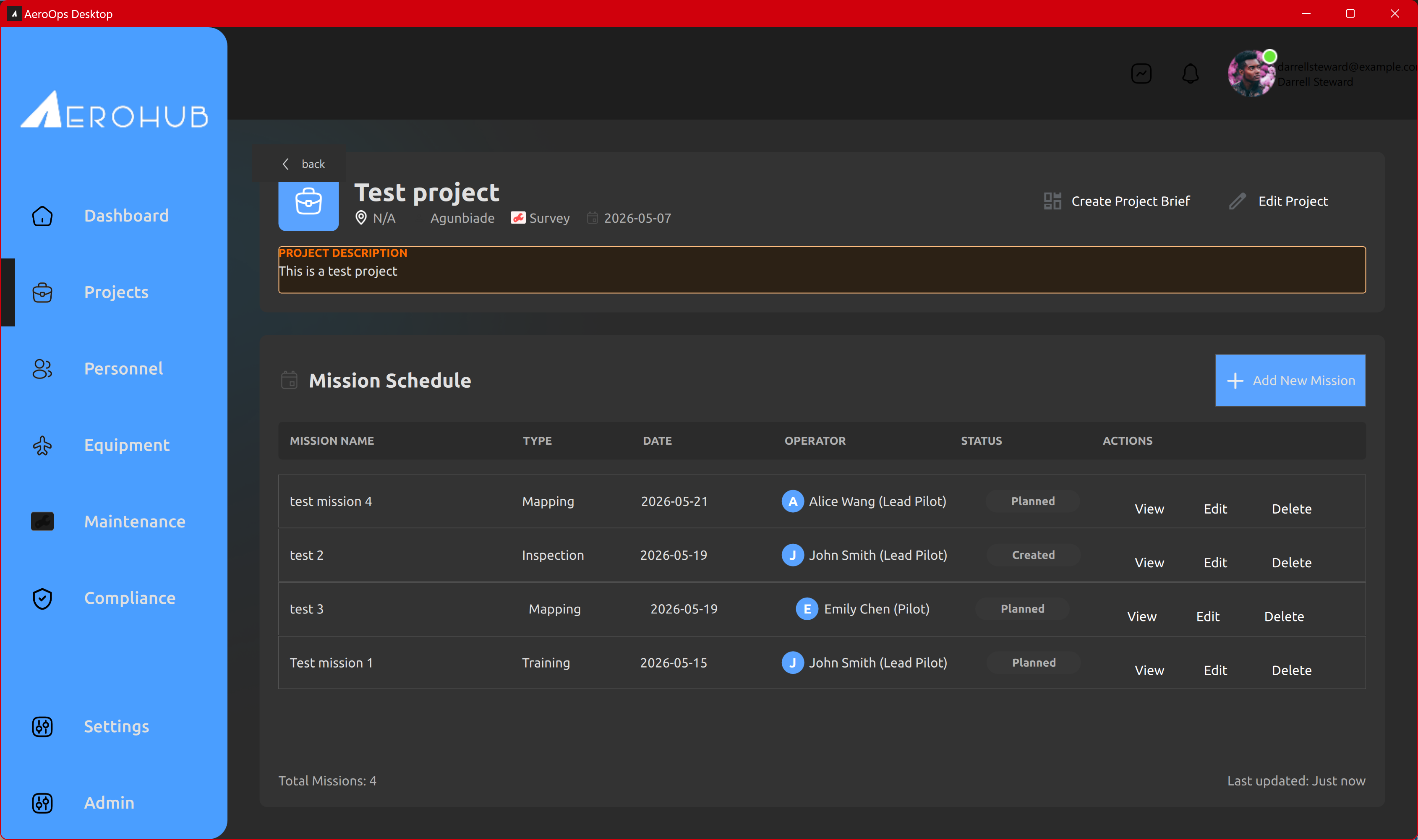
4. Collaborative Mission Planning
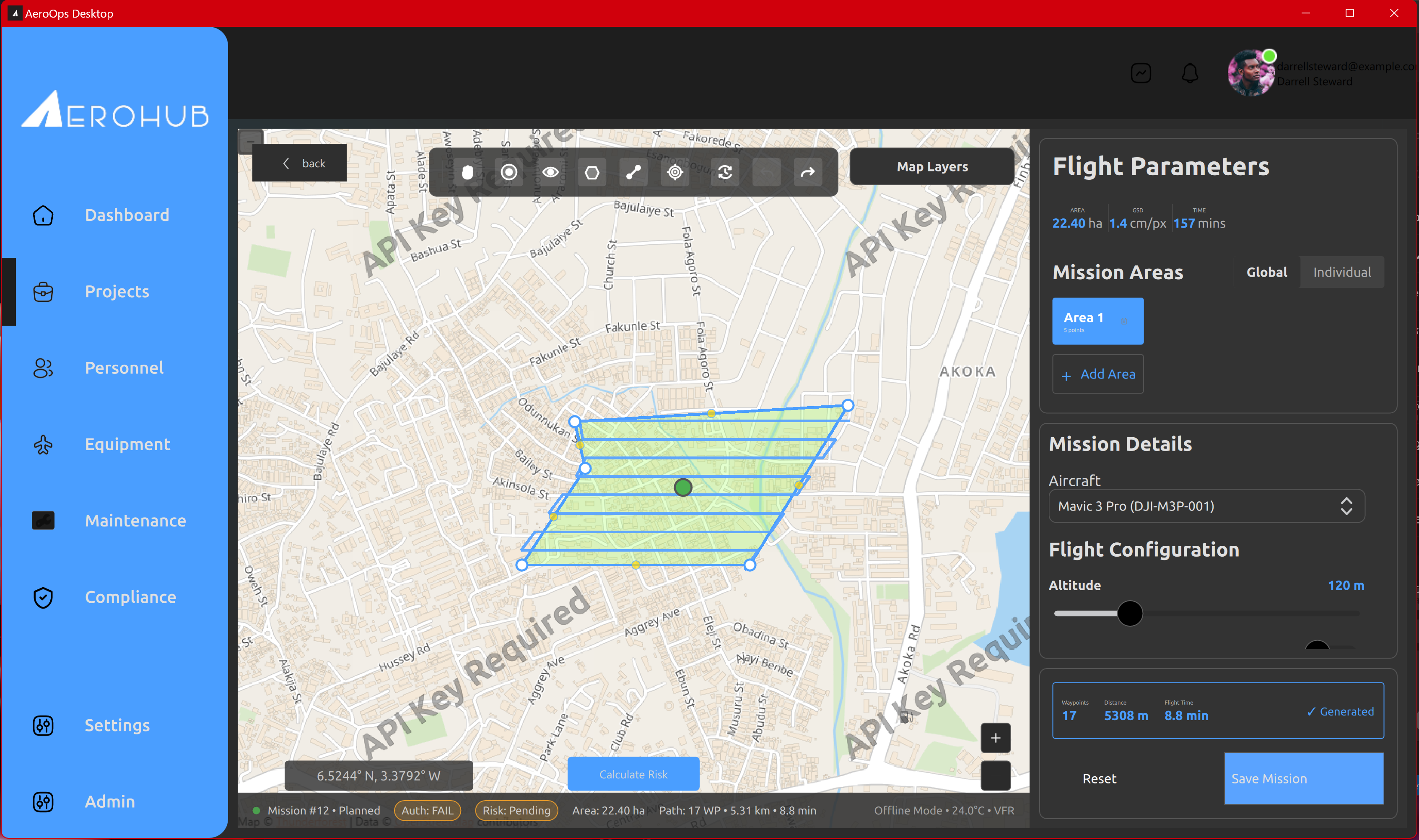
Design and share mission profiles across your team. Whether it’s a standard grid survey or a complex linear inspection, AeroOps allows engineers to pre-define flight paths, waypoints, and payload settings, which pilots can then execute with precision in the field.
5. Weather & UTM Integration
Safety and compliance start before takeoff. AeroOps pulls real-time weather forecasts and Unmanned Traffic Management (UTM) data directly into the mission planning and pre-flight workflow. Pilots can view airspace restrictions, secure authorizations, and check micro-weather conditions without leaving the platform.
6. AI-Driven Risk Mitigation
AeroOps leverages machine learning to actively protect your fleet. By analyzing historical flight logs, real-time weather patterns, and hardware telemetry, the system’s AI evaluates the parameters of upcoming missions to dynamically calculate risk scores, flagging potential hazards—such as equipment fatigue or incoming weather fronts—before the props even start spinning.
The Target Market
AeroOps is engineered specifically for organizations that treat drones as mission-critical enterprise tools. Our primary users include:
- Drone Service Providers (DSPs): Companies managing multiple pilots and scaling their enterprise contracts.
- GIS and Surveying Firms: Teams that require tight integration between flight execution and rigorous spatial data processing.
- NGOs and Research Labs: Organizations running complex, data-heavy humanitarian or environmental mapping missions.
- Enterprise In-House Teams: Large-scale operations in agriculture, oil & gas, and infrastructure inspection that need robust oversight and compliance tracking.
Elevate Your Operations
Building the hardware and the software to manage a fleet is a rigorous engineering challenge, and fragmented systems only slow down your ability to scale. AeroOps is designed to remove that friction, allowing your team to focus on executing the mission rather than managing the paperwork.
If your company is struggling with operational bottlenecks, disconnected data, or the growing pains of managing a commercial drone fleet, we can help streamline your workflow.
Reach out today for more information, a technical deep dive, or a demonstration of how AeroOps can optimize your fleet operations.
For AeroOps, our website is https://aerohubworks.com/aeroops so that users can get in touch with us. You can also send us a mail at admin@aerohubworks.com. Users can also directly contact the company page on LinkedIn to get in touch - linkedin.com/company/aerohub-uav-solutions.